Get the Top, Local stories delivered to your inbox! Click here to join the daily Vernon Matters newsletter.
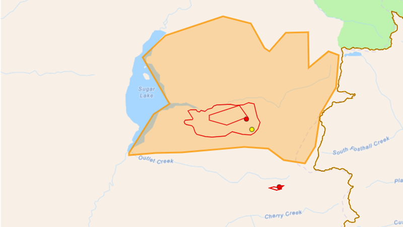
The Sitkum Creek wildfire has grown to 350 hectares (the orange boundary represents the Evacuation Alert area) (image courtesy of the B.C. Wildfire Service)
1,501 hectare wildfire

UPDATE: Sitkum Creek still 1,500 hectares in size, can’t be reached by ground crews

Jul 23, 2024 | 11:16 AM

UPDATE 4:30 p.m. July 23

The Sitkum Creek wildfire east of Sugar Lake remained estimated at 1,500 hectares in size Tuesday afternoon.

The Out of Control wildfire northeast of Cherryville, which was suspected of being caused by lightning, was discovered on the afternoon of July 18, and had grown significantly since then.

It was first estimated at 58 hectares Friday and not updated again until 10 p.m. Monday, when it was said to be 350 hectares in size, before jumping to 1,501 hectares as of noon Tuesday.

“The Sitkum Creek wildfire is located 63 kilometres northeast from Vernon, it’s now estimated to be around 1,500 hectares in size” Ayden Coray, a Fire Information Officer with the B.C. Wildfire Service, told Vernon Matters at around 4:20 p.m. Tuesday, July 23.

“This fire has seen considerable growth over the last 72 hours in particular, and visibility in the area from the smoke has been impacting our ability to accurately map the size of the wildfire in the last few days.”

Though located close to Sugar Lake, wildfire crews are not able to get to the blaze.

“Currently we don’t have any crews or resources on the ground there, this is because our public and responder safety and our number one priority when responding to any incidents, and right now the wildfire is burning in terrain that is inaccessible to our crews in a way that it wouldn’t be safe for them to retreat should they need to,” Corey explained.

“Particularly, the western flank of the fire is burning in an area that’s unsafe for our crews to action directly. So once that activity on the western flank that is closes to Sugar Lake is in a place where crews can have access off the road systems in the area, then that will be when they can action it safely.”

The Fire Information Officer noted there were Structure Protection Crews assigned to the fire to make sure structures on the west and south side of Sugar Lake would be protected, while a helicopter and response officer were monitoring the fire from the air to assess the growth and determine if there were any way for firefighters to access the blaze.

There weren’t any bucketing helicopters, air tankers or skimmers assigned to the fire as of Tuesday afternoon.

The Regional District Of North Okanagan issued an Evacuation Alert for the Sugar Lake recreation area Monday evening, and that remained in place as of Tuesday afternoon.

UPDATE 1:15 p.m. July 23

The wildfire near Sugar Lake grew almost five fold Tuesday morning.

The B.C. Wildfire Service reported the fire north of Cherryville was 1,501 hectares in size as of 12:06 p.m. July 23.

That was nearly five times the size of the 350 hectare fire that was first reported at 10 p.m. Monday night, and confirmed by the BCWS Tuesday morning.

The BCWS had not assigned any resources to the fire Tuesday morning as it was located in an inaccessible area and not posing a threat to any structures. Vernon Matters has inquired as to if any resources had been assigned Tuesday afternoon as the fire had grown significantly, but the BCWS did not immediately respond to the request for comment.

The Regional District of North Okanagan issued an Evacuation Alert for the Sugar Lake recreation area Monday evening before the fire was reported to have grown.

The Out of Control wildfire was suspected of being caused by lightning.

Original Story

A wildfire that’s burning east of Sugar Lake near Cherryville near has grown significantly.

The B.C. Wildfire Service said the Sitkum Creek wildfire grew to 350 hectares in size as of 10:50 p.m. Monday, July 22.

The B.C. Wildfire Service estimated the fire was 58 hectares the previous Friday and there were no updates over the weekend, but a BCWS fire information officer told Vernon Matters an aircraft surveyed the fire and had the new estimated size Monday night.

The fire, which is classified as Out of Control, is suspected of being caused by lightning strike.

The BCWS added no resources were assigned to that fire due to it being in inaccessible terrain, though noted the aircraft teams continue to monitor the fire.

That fire did result in an Evacuation Alert being issued for the Sugar Lake recreation area Monday evening.

Meanwhile, a 24-hectare wildfire in a similar area east of Sugar Lake was being actioned Monday morning.

The BCWS stated a nine-person ground team was assigned to that fire, which was also classified as Out of Control and suspected of being caused by lightning.

The Mara Mountain wildfire was still estimated at 220 hectares Monday morning, and resources have still not been assigned to it.

The fire information officer noted BCWS crews were assisting with the fire near Sorrento that led to a precautionary Evacuation Alert being issued for over a dozen properties.

View Comments