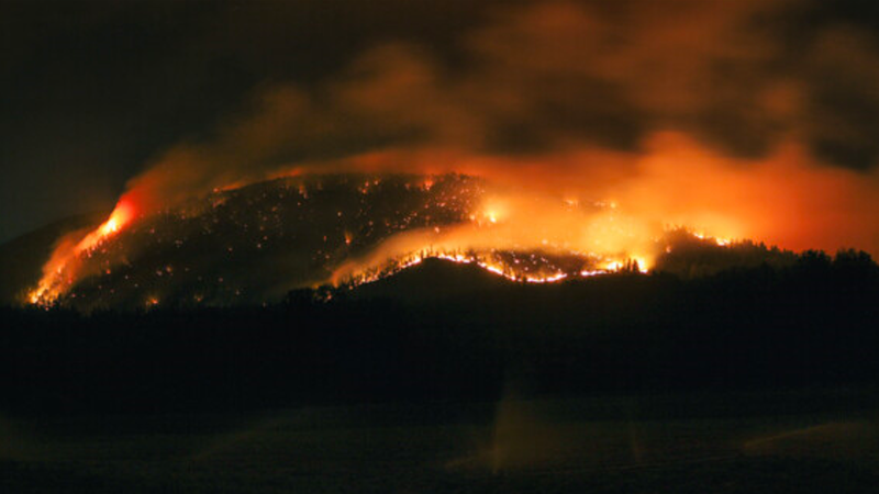
The Hullcar Mountain wildfire (photo courtesy of the Splatsin First Nation / website)
Wildfire Activity

Further growth reported at Hullcar Mountain wildfire, Evacuation Alerts unchanged

Aug 6, 2024 | 10:45 AM

The fire near the Splatsin First Nation saw significant growth Monday night.

The B.C. Wildfire Service (BCWS) reported the Hullcar Mountain fire as being 330 hectares in size as of 9:39 a.m. Tuesday, August 6.

The provincial firefighting agency told Vernon Matters said the wind was a contributing factor the the spreading fire Monday.

The BCWS said it was responding with six Initial Attack Crews, one rappel crew, and one wildfire officer Tuesday morning.

There were also three helicopters assigned to the fire, and the BCWS said it had put in a request for an airtanker group, consisting five skimmers located in the area, Tuesday morning. The aerial resources were tasked with working on the northeastern flank.

A machine guard was also established Monday on the south and western flanks, with the BCWS saying a hose lay would be put down in the area.

Several Evacuation Alerts were issued due to the growing fire Monday afternoon by the Splatsin First Nation, Township of Spallumcheen, and Columbia Shuswap Regional District (CSRD). Those alerts were unchanged as of Tuesday morning and included the following properties:

  • Splatsin First Nation
    • All properties on Felix Road
    • All properties on Salmon River Road
    • All properties on Clcahl Road
    • All properties on Hullcar Road
    • All properties on Williams Road
  • Township of Spallumcheen
    • The following addresses on Hullcar Road: 4194, 4222, 4236, 4254, 4256, 4257, 4260, 4264, 4265, 4267, 4268, 4276, 4279, 4288, 4296, 4306, 4310, 4316, 4320, 4342, 4350, 4362, 4382, 4402, 4420, 4430, 4466, 4504, 4516, 5004
    • 5193 Parkinson Road
    • The following address on Deep Creek Road: 5353, 5315, 5233
    • All properties on Todd Place
    • All properties on Frederick Road
  • CSRD
    • 2232 to 2310 Deep Creek Road
    • 2839 Forbes Road
    • The following properties on Salmon River Road: 2033 to 2621, as well as 2702, 2833, 2913, 2964

The local governments and First Nations noted these were Evacuation Alerts, and advised people be prepared to leave with grab-and-go bags should the situation change.

The CSRD also stated there had been reports of heavy traffic on Salmon River Road as people stopped to take pictures and video of the wildfire, and on Tuesday requested non-residents not use the road so that people under the Evacuation Alerts have a safe route to move their livestock and other items out of the area.

The Township of Spallumcheen also said Tuesday that local fire crews would be patrolling the area throughout the day with the BCWS crews action the blaze.

The fire was reportedly discovered Saturday, August 4, and was suspected of being caused by lightning. It remained classified as Out of Control as of Tuesday.

Elsewhere in the North Okanagan and Shuswap, the two other large fires were unchanged over the weekend.

The BCWS stated the Sitkum Creek wildfire, east of Sugar Lake and northeast of Lumby and Cherryville, was still estimated at 1,269.1 hectares and classified as Out of Control, with the Evacuation Alert still in place for the eastern side of the Sugar Lake recreation area.

As of Tuesday morning the BCWS had 27 personnel assigned to that blaze, including two danger tree fallers, who were working on a 50 foot black line, or a fuel break through small-scaled controlled hand-ignitions or direct removal of fuels on the western flank.

The Mara Mountain wildfire, east of Sicamous, was also still estimated at 281.4 hectares and considered Out of Control, and the BCWS said there were no resources assigned to the blaze Tuesday morning.

View Comments