Get the Top, Local stories delivered to your inbox! Click here to join the daily Vernon Matters newsletter.
Light snow in Vernon (stock photo by Liam Verster / Vernon Matters)
86% of Normal

Okanagan snowpack higher, but still below normal

Feb 8, 2024 | 1:35 PM

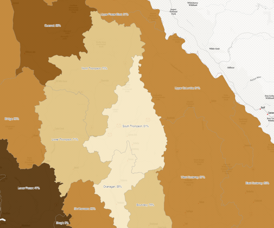
The Okanagan has one of the deepest snowpack rates in the province, but it’s still below normal levels.

The B.C. River Forecast Centre snowpack update showed that the Okanagan Basin had a snowpack equating to 86 per cent of the average as of Feb. 1, 2024.

That was down from the same time last year when the basin was 121 per cent of normal.

When comparing to the average snowpack, the only region with a higher rate in the most recent report was Stikine at 90 per cent. The South Thompson Basin had the third largest snowpack at 81 per cent of normal.

Elsewhere in the Interior region, the snowpack rates compared to the average were:

  • Boundary, 75 per cent of normal
  • North Thompson, 73 per cent
  • Lower Thompson, 71 per cent
  • West Kootenay, 67 per cent
  • East Kootenay, 63 per cent
  • Upper Columbia, 61 per cent
  • Upper Fraser East, 61 per cent
  • Similkameen was 60 per cent
  • Bridge, 60 per cent
  • Quesnel, 55 per cent
    Snowpack rates as of Feb. 1 2024 (graphic courtesy of the B.C. River Forecast Centre)

The basins with the lowest snowpack compared to normal was Skagit at 0 per cent, followed by Vancouver Island at 30 per cent and South Coast at 41 per cent.

As of February 1, the provincial snowpack was averaging at 61 per cent of normal. This time last year, the rate was 79 per cent of normal.

The River Forecast Centre warns the low snowpack could cause mitigate some issues in the coming months, though could have longer term impacts.

“Due to the extremely low snow conditions, below normal spring freshet flood hazard is expected this season, especially in the Interior,” the agency stated.

“Low snowpack and seasonal runoff forecasts combined with warm seasonal weather forecasts and lingering impacts from previous drought are creating significantly elevated drought hazards for this upcoming spring and summer.”

It was noted that while there remains another two or three months for potential snowfall, the current low snowpack conditions are expected to continue.

Premier David Eby said Thursday he’s “really worried” about the coming summer, adding the extreme weather B.C. is experiencing is an “early warning sign for the rest of Canada about what’s coming with climate change.”

View Comments