Get the Top, Local stories delivered to your inbox! Click here to join the daily Vernon Matters newsletter.
New proposed area for Vernon-Monashee federal electoral district (in yellow) (Image credit: Federal Boundaries Commission)
Vernon-Monashee

Proposed new federal riding would not split Greater Vernon

Feb 14, 2023 | 10:00 AM

A Vernon business group is pleased a federal committee has backed off plans to split Greater Vernon into two federal electoral districts.

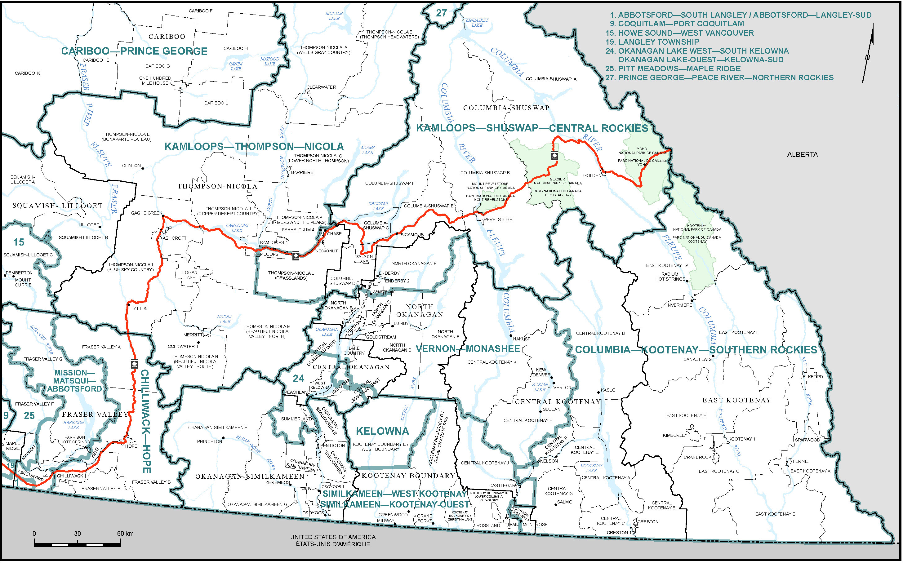
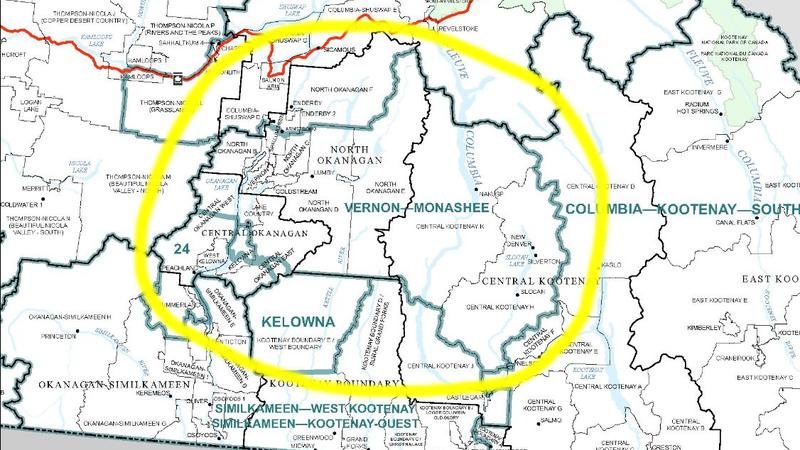
The Federal Electoral Boundaries Commission has tabled a report that would keep Greater Vernon in a single electoral district, while adding new communities to the riding and giving it a new name, Vernon-Monashee, which is also what the current provincial riding is called.

The Greater Vernon Chamber of Commerce is calling it an advocacy win after it urged the boundaries commission last year to not separate Vernon, Coldstream and Areas B and C between two federal ridings. There are common services between the jurisdictions such as water, parks and culture, and the fact that Greater Vernon is a single economic and social unit.

“We were concerned that having two electoral districts would create challenges for businesses, local governments and residents trying to access federal services as they would have to communicate with two Members of Parliament,” Robin Cardew, Greater Vernon Chamber president, said.

On Feb. 8, the Federal Boundaries Commission presented a report to the House of Commons that calls for the new riding to include all of Vernon, Coldstream and Areas B and C, as well as Lake Country, North Westside Road, half of Spallumcheen, Lumby, Cherryville, Nakusp and New Denver.

“We thank the boundaries commission for reflecting on the unique nature of Greater Vernon and maintaining it as a single unit when it comes to federal elections. This is just another example of the strong voice the Chamber has provided its members since 1897,” Cardew said.

“Advocacy is an essential part of our mandate, and we will continue to ensure that all levels of government are aware of the needs of our members and the community.”

Armstrong and Enderby, which are in the current North Okanagan-Shuswap riding, would not be in Vernon- Monashee, but rather in Kamloops-Shuswap-Central Rockies.

Part of Spallumcheen would be in Vernon-Monashee and part in Kamloops-Shuswap-Central Rockies.

The boundary commission’s report will now be reviewed by the House of Commons Standing Committee on Procedure and House Affairs, prior to MP’s voting on the proposal.

According to the report, the population of the revised Vernon-Monashee riding would be 108,606.

It will consist of:

  1. that part of the Columbia-Shuswap Regional District comprising:
    1. Okanagan (Part) Indian Reserve No. 1;
  2. those parts of the Regional District of Central Kootenay comprising:
    1. Central Kootenay electoral areas H and K;
  3. those parts of the Regional District of Central Okanagan comprising:
    1. that part of Central Okanagan East Electoral Area lying northerly and easterly of Highway 33 East;
    2. that part of Central Okanagan West Electoral Area lying northerly of a line described as follows: commencing at the easterly limit of said electoral area in Okanagan Lake at approximate latitude 50°02’26″N and longitude 119°28’26″W; thence westerly in a straight line to the westerly shoreline of Okanagan Lake at an unnamed creek at approximate latitude 50°02’18″N and longitude 119°29’58″W; thence westerly along said creek to Westside Road North; thence northerly along said road to Cinnabar Creek; thence generally westerly along said creek to a point at approximate latitude 50°02’16″N and longitude 119°31’22″W; thence westerly in a straight line to the westerly limit of said electoral area at approximate latitude 50°03’22″N and longitude 119°45’35″W;
    3. the District Municipality of Lake Country; and
    4. Duck Lake Indian Reserve No. 7; and
  4. those parts of the Regional District of North Okanagan comprising:
    1. North Okanagan electoral areas B, C, D and E;
    2. the District Municipality of Coldstream;
    3. that part of the District Municipality of Spallumcheen lying southerly of a line described as follows: commencing at the intersection of the easterly limit of said district municipality and Reservoir Road; thence westerly along said road to Powerhouse Road; thence generally southwesterly along said road to Highway 97A; thence northerly along said highway to the southerly limit of the City of Armstrong; thence westerly, generally northerly, generally westerly and northerly along the limit of said city to Sutton Creek; thence generally northwesterly and southwesterly along said creek to a point at approximate latitude 50°27’24″N and longitude 119°15’57″W; thence northwesterly in a straight line to the southeast corner of Salmon River Indian Reserve No. 1 at approximate latitude 50°28’17″N and longitude 119°17’51″W;
    4. the City of Vernon; and
    5. Okanagan (Part) Indian Reserve No. 1.
Proposed new electoral district map of south eastern B.C. (Image credit: Federal Boundaries Commission)

Click here for a larger version of the map.

View Comments