(Liam Verster / Vernon Matters Staff)
Arctic Air Blast

Chill out: Vernon’s first cold snap of season on the way

Jan 10, 2024 | 1:20 PM

The mild winter weather Vernon and the Okanagan has so far experienced is expected to come to an end in the coming days, but the cold snap won’t last long.

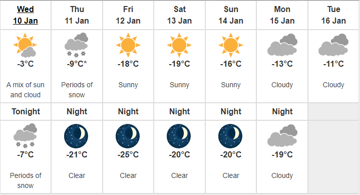
Speaking with Vernon Matters Wednesday, Jan. 10, Alyssa Charbonneau, a meteorologist with Environment Canada, said the temperature will be driven down as an arctic air blast hits Vernon and the entire province.

“What we are looking at is that typical situation that brings us really cold air, that arctic outbreak, as we see cold air move from the north across British Columbia, and it’s expected to make its way right down to the south and even out to the coast, so pretty much all of B.C. is in for a stretch of much below normal temperatures,” Charbonneau said.

“In the Vernon area, we’re looking at temperatures today (Wednesday) kind of near normal but tonight and tomorrow, we start to see that cold air reach you. And looking at tomorrow night, overnight lows of -21 and then Friday and Saturday, looking at the coldest day with daytimes highs hovering around -20 and overnight lows even lower than that, and then things kind of to gradually start to moderate as we get into the early part of next week.”

Vernon’s seven day forecast (image courtesy of Environment Canada)

Charbonneau said the mercury is expected to climb back to seasonal temperatures following the cold snap, which is typically around a daytime high of -2 and an overnight low of -8, though she noted the several days of cold may feel especially harsh coming off the mild winter Vernon has seen so far.

Though the system will bring the temperature down, it’s not expected to bring much local snow.

“As the arctic air arrives, it’s usually accompanied by a bit of snow, some flurries, some gusting winds as well. We are looking at 2 to 4 centimetres tonight, another 2 cm in the forecast tomorrow potentially,” Charbonneau said.

“But then after that, arctic air settles into place and it’s very dry, so we aren’t expecting a lot of snow for Friday or through the weekend.”

Charbonneau noted people should keep an eye on the local forecast as the system may result in some alerts being issued.

She noted once the arctic air moves out of the region, some moisture from the coast could roll into the Okanagan Valley, bringing with it some precipitation, but added it was still too early to confirm snowfall next week.

Environment Canada lifted its winer storm warnings for the Coquihalla and Highway 3 Wednesday, and while the arctic blast is not expected to bring much new snow, the highways could still be hazardous during the cold snap.

“Any time you’re driving in these very cold conditions you want to make sure you’re properly prepared and carrying an emergency kit because conditions will be very difficult,” Charbonneau told Vernon Matters.

“The other thing to remember is, as this cold air moves in, you could get some gusting winds and you could get some flurries which could briefly really reduce visibility, and when it’s really cold, you have to think about the potential for icy, slippery surfaces on those highways.”

Road conditions can be checked on the DriveBC website.

The Environment Canada meteorologist added B.C. is still facing an El Niño system, and it’s expected to persist through the rest of the winter and into the spring.

“That still gives us a clue that, on a whole, this winter is more likely to be milder than normal, and we’ll see if we see that flip back,” Charbonneau said.

“Some of our long-range forecast models have been showing that after next week we get into more near normal and them maybe warmer than normal conditions in the long range, but we’ll have to see how that all plays out.”

View Comments