Get the Top, Local stories delivered to your inbox! Click here to join the daily Vernon Matters newsletter.
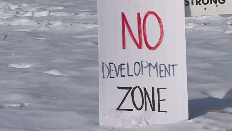
Oppositon to rezoning in Armstrong (photo credit: Global News)

Armstrong chooses site for affordable housing

Jan 29, 2021 | 7:00 AM

The City of Armstrong has approved the rezoning of land for the purpose of providing a site for affordable housing.

The rezoning includes a 0.835-ha forested parcel of parkland south of NorVal Arena for up to 80 units of affordable housing.

The following was issued by the city on the decision which was controversial as some residents did not want to see park land used for an affordable housing project:

Why did Council make this move?

Council has for many years considered the nine lots along Poole Street as the ideal site for a housing project due in large part to the proximity to schools and recreation facilities. Council has also had affordable housing as its top strategic goal for several years. As part of the process to update our Official Community Plan (OCP), current legislation requires the inclusion of a housing needs analysis. This was prepared regionally by the Regional District of the North Okanagan (RDNO) and adopted by Council on August 10, 2020. That report identified a critical need for rental housing in the City of Armstrong of 140 rental units and 65 ownership units. Taking a closer look at the land Council opted to include a larger parcel to assist in our potential response to the Housing Needs Assessment.

What Changed?

The City changed the zoning from Park and Open Space to Residential Medium Density RM.4 The City also changed the OCP from Park to Multiple Unit Residential (Medium Density).

Why did the Zoning and OCP say it was a park?

When the City decided to review a new OCP in the mid-nineties, a large number of studies were put together to determine the state of the City. Among the studies, was consideration of a Parks and Recreation Master Plan, which kicked off with a public survey process through the early nineties, and was finally published in 1994. This plan identified the need for the City to inventory all natural and open spaces and to separate them from the other portions the City was intending to use for park purposes. The reason for this was so the City could ensure that natural areas received protection under Development Permit requirements. The idea of an inventory was included as a goal in the OCP that was finally adopted in 1996, but the separation between active parkland and open spaces was never carried through. In 2014 when the new OCP was adopted, it also did not differentiate between active park and more passive open space, and the classification of the land was repeated as Park. The City has no documentation that the property was ever considered to be for future expansion of Memorial Park and therefore Council considered it for civic purposes to meet our strategic plans goals.

Parkland vs. Open Space?

The rezoned land has never been developed as part of a park. The main body of the rezoned land was purchased by the city from three landowners as part of the land assembled for the Adair Sewer plant in 1964. This land has remained largely unimproved by the City, except to install a storm interceptor ditch to benefit the arena project, and was never maintained as park or used for this purpose since its purchase by the City in 1964. Local Governments are free to buy sell and trade land under legislation. Land dedicated as park has special rules that only apply where the land has been dedicated as a park, as a condition of subdivision approval under Section 510 of the Local Government Act. The land in question was never dedicated to that purpose, but rather was purchased as part of a larger parcel for other civic purposes.

View Comments